716: 1/2 What if the San Jacinto Fault ruptured along with the San Andreas Fault. Julian C. Lozos, CSUN. @ScienceMagazine
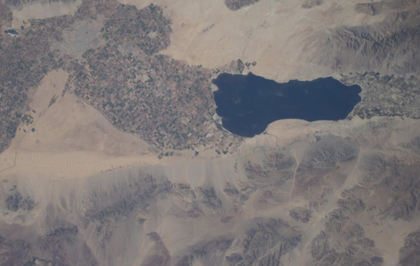
Photo: No known restrictions on publication. 2014. ISS040-E-114379 (31 Aug. 2014) --- One of the Expedition 40 crew members aboard the Earth-orbiting International Space Station, flying at an altitude of approximately 225 nautical miles, photographed this image of California's Salton Sea on Aug. 31, 2014. The body of water is actually a shallow, saline, endorheic rift lake located directly on the San Andreas Fault, predominantly in the Imperial and Coachella Valleys. http://JohnBatchelorShow.com/contact http://JohnBatchelorShow.com/schedules Parler & Twitter: @BatchelorShow 1/2 What if the San Jacinto Fault ruptured along with the San Andreas Fault. Julian C. Lozos, CSUN. @ScienceMagazine http://advances.sciencemag.org/content/2/3/e1500621.full Abstract: The San Andreas fault is considered to be the primary plate boundary fault in southern California and the most likely fault to produce a major earthquake. I use dynamic rupture modeling to show that the San Jacinto fault is capable of rupturing along with the San Andreas in a single earthquake, and interpret these results along with existing paleoseismic data and historic damage reports to suggest that this has likely occurred in the historic past. In particular, I find that paleoseismic data and historic observations for the ~M7.5 earthquake of 8 December 1812 are best explained by a rupture that begins on the San Jacinto fault and propagates onto the San Andreas fault. This precedent carries the implications that similar joint ruptures are possible in the future and that the San Jacinto fault plays a more significant role in seismic hazard in southern California than previously considered. My work also shows how physics-based modeling can be used for interpreting paleoseismic data sets and understanding prehistoric fault behavior.