142: New York at War: 2of4: Four Centuries of Combat, Fear, and Intrigue in Gotham 1st Edition. by Steven H. Jaffe (Author)
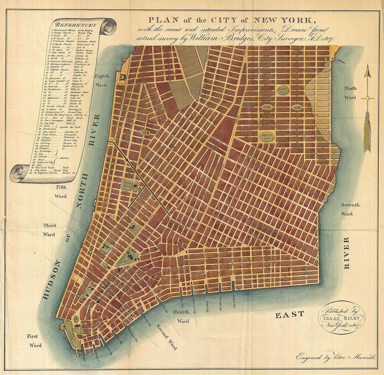
Image: Plan of the City of New York, with the recent and intended Improvements, Drawn from actual survey by William Bridges City Surveyor; AD 1807. Description | English: An interesting and unusual map, this is William Bridges’ 1807 revival or the failed 1801 Mangin-Goerck Plan. Those who know New York’s shoreline will pause at the perfect blocks and ridged angles of this plan no more accurate today than it was in 1801 when Mangin first presented it. Mangin, a talented French architect, and Goerck, an established New York Surveyor, were commissioned by the Common Council of New York to prepare a new regulatory map of the city. Though Goerck passed away before the plan could be completed, Mangin finished the plan on a grand scale, re-envisioning New York City in his own image. Mangin even added streets such as Mangin Street and Goerck Street which would have been submerged under the East River had they actually existed (as a side note another of Mangin’s Street’s, South Street, did eventually appear). The Mangin-Goerck plan went far beyond the Common Council’s dreams of an administrative plan and, due to its inclusion of “intended improvements”, new streets, and idealized block structure, enjoyed a short lifespan. It is curious then that in 1807 William Bridges, the talented City Surveyor who, in 1811, laid New York’s famous grid structure, resurrected and pirated the Mangin-Goerck Plan, attaching his own name to it. It was a private venture that led Bridges to piracy. He was commissioned by Dr. Samuel Mitchell to provide a map to illustrate Mitchell’s Picture of New York , a travel guide intended for foreign tourist. Perhaps Bridges chose the Mangin plan simply because, as a failed city plan, there were few obstacles to his use of it, but we do pity the hapless tourists who leapt into the east river in pursuit of Mangin Street. Though originally issued in 1807 for S. Mitchell’s Picture of New York , this example is a reissue prepared by John Hardy, Clerk of the Common Council, for the 1871 edition of the Manual of the Corporation of New York . Date | 1807 (1871 reissue) Dimensions | Height: 12.5 in (31.7 cm); Width: 13 in (33 cm) Accession number | Geographicus link: NewYork-bridges-1871 (http://www.geographicus.com/P/AntiqueMap/NewYork-bridges-1871) Source/Photographer | Hardy, John, Manual of the Corporation of the City of New York, 1871. Also in: Mitchell, S. L., The Picture of New-York, or The Traveller's Guide, 1807. New York at War: 2of4: Four Centuries of Combat, Fear, and Intrigue in Gotham 1st Edition. by Steven H. Jaffe (https://www.amazon.com/Steven-H-Jaffe/e/B001KHHCNU/ref=dp_byline_cont_book_1) (Author) https://www.amazon.com/New-York-War-Centuries-Intrigue-dp-0465036422/dp/0465036422/ref=mt_other?_encoding=UTF8&me=&qid=1593834185 Stretching from the colonial era to 9/11 and beyond, New York at War is that most rare of books: a work of history that is at once local and international, timely and timeless. Bringing a unique lens to bear on the world's most celebrated and contested city, Jaffe reveals the unimaginable ways the city has changed—and how it has stubbornly endured—under threats both external and internal.