Hurricane Ian: Monday evening update
b"
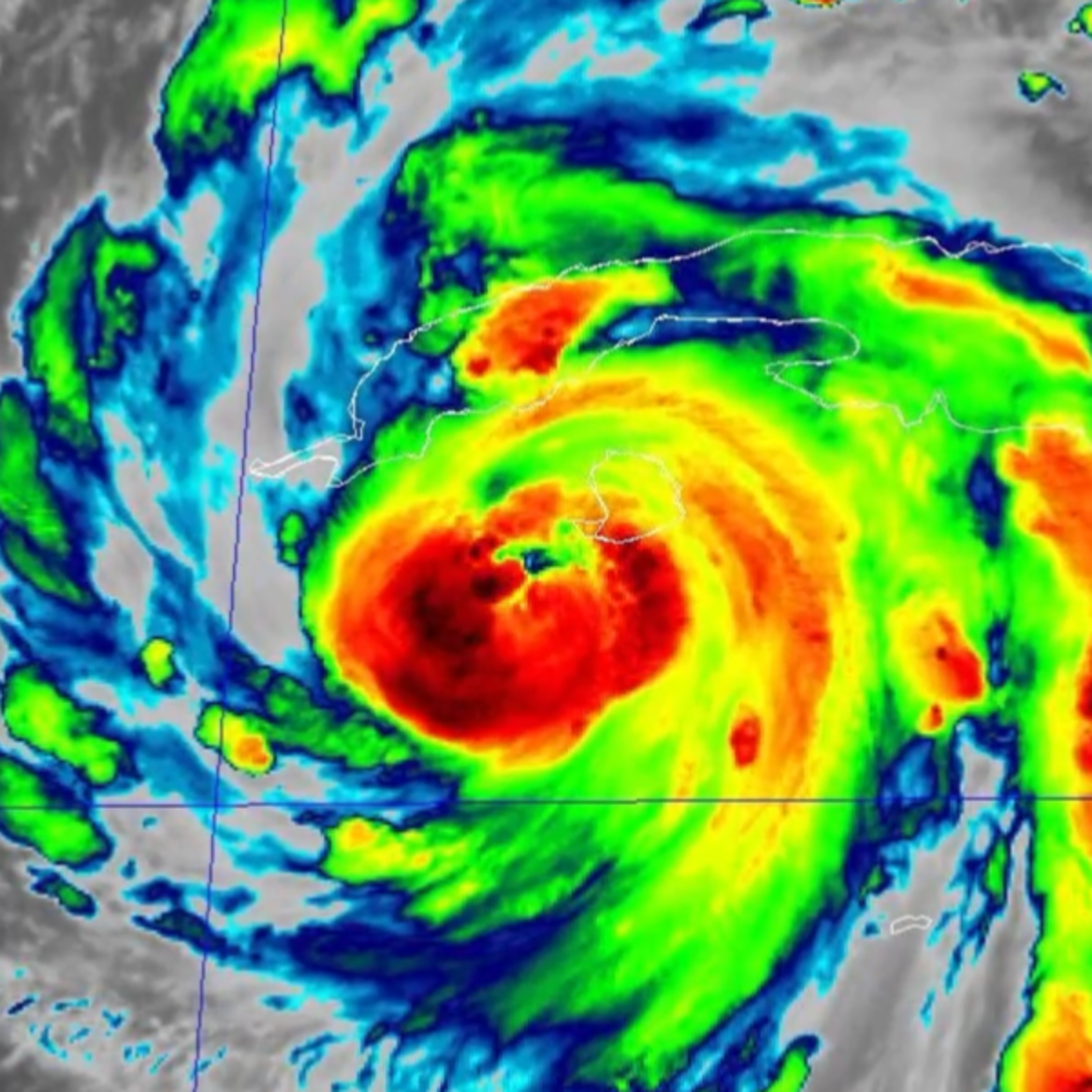
Hurricane Ian is growing in strength ahead of landfall in Florida later this week.
\\nThere is still uncertainty in the forecast for Ian. As the storm's track progresses, there will be a better certainty of where and when the storm makes landfall. This data will allow forecasters to better and more accurately predict what happens to Ian as it approaches Georgia, South Carolina, and North Carolina.
\\nBoth the NAM and a European weather forecast model envision a landfall near Tampa with the storm passing over Orlando and the space coast before returning to the Atlantic Ocean. This would put the storm closer to cities like Savannah, Hilton Head, Charleston, Myrtle Beach, and Wilmington. This scenario would bring more beach erosion and heavier surf to the Carolina coast.
\\nThe GFS model wants to take the storm further west and further inland following landfall in Florida's panhandle. If Ian's center of circulation were to pass over Georgia, upstate South Carolina, and western North Carolina, more of the Carolinas would see more severe weather.
\\nIn either scenario, all of the Carolinas are at risk for heavy rain and flash flooding.
\\nThe strongest part of any storm is the top right, or northeast, quadrant. A storm track further west puts more of the Carolinas under the right side of the storm. Thus this would bring more of Ian's heavy rain, flash flooding, strong winds, and possible tornado threat further inland and over more of the Carolinas.
\\nThe certainty in the forecast will improve over the coming days. In any scenario, impacts from Ian are not expected to reach the Carolinas before late Thursday with the most likely arrival overnight on Friday. Impacts will move from south-to-north with storm impacts reaching North Carolina by later Friday. Storm impacts will continue into Saturday and linger into Sunday.
\\nThe Carolina Weather Group will continue to track Ian, the forecast, and the impacts that can be expected in the Carolinas. Now is the time to prepare for possible evacuations, power outages, flooding, and more.
\\nLEAVE A TIP: https://streamelements.com/carolinawxgroup/tip
\\nSUBSCRIBE TO OUR PODCAST: https://anchor.fm/carolinaweather
\\nSUPPORT US ON PATREON: https://patreon.com/carolinaweathergroup
\\nVISIT OUR WEBSITE: https://carolinaweathergroup.com
\\nThe Carolina Weather Group operates a weekly talk show of the same name. Broadcasting each week from the Carolinas, the show is dedicated to covering weather, science, technology, and more with newsmakers from the field of atmospheric science. With co-hosts across both North Carolina and South Carolina, the show may closely feature both NC weather and SC weather, but the topics are universally enjoyable for any weather fan. Join us as we talk about weather, environment, the atmosphere, space travel, and all the technology that makes it possible.
\\n\\n--- \\n\\nSend in a voice message: https://podcasters.spotify.com/pod/show/carolinaweather/message"